


East winds give Ken Endean a chance to explore unfrequented parts of one of Britain’s prettiest archipelagos - the Isles of Scilly
People who sail to the Isles of Scilly are inclined to smile and turn misty-eyed when describing this delightful, compact cruising ground.
Pristine sands, glass-clear water, craggy coastal scenery and sub-tropical vegetation: if we can’t get to the Pacific islands then Scilly is a good alternative.
Admittedly, some prospective visitors are deterred because no single anchorage or mooring area offers complete, all-round shelter.
Even so, for Isles of Scilly regulars, that simply adds spice to their holiday and gives good reasons for moving around from place to place according to the wind direction.
An easterly airflow produces interesting conditions because the prevailing winds, and most of the gales, come out of the south-west quadrant and the traditional anchorages and harbours took that into account.

The dinghy pontoon is in the sheltered corner of Hugh Town harbour on St Mary’s, Isles of Scilly. Credit: Ken Endean
Old Town, on the eastern side of St Mary’s, was the medieval harbour; it dried at low tide but faced away from worst weather, and Hugh Town, on the western side of the island, only became a useful port when its breakwater was constructed.
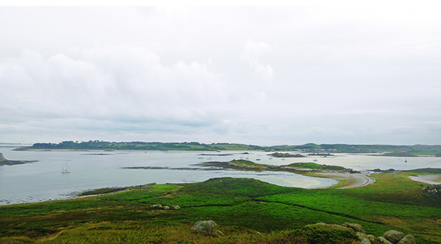
New Grimsby Sound has always been the best deep-water anchorage for small craft and has Bryher island for protection from the ocean.
Modern pilotage guidance still tends to give most prominence to anchorages that provide shelter from south-west winds.
East winds therefore add variety by providing a chance to enjoy other places, including some that become wonderfully snug havens when the Atlantic turns placid.
Next door to Hugh Town, Isles of Scilly
The best-protected part of Hugh Town harbour is full of local moorings and the visitor buoys on the northern side are exposed to the west and distinctly uncomfortable in westerly winds.
In east winds these moorings become much more peaceful but also very popular.
The obvious alternative, slightly further north, is the anchorage in Porth Loo, between Taylor’s Island and Newford Island.
It is not foolproof, because there is a drying outlier west of Taylor’s Island and some boulders on the sea bed, but the water is usually clear enough to reveal patches of sand between the lumps.

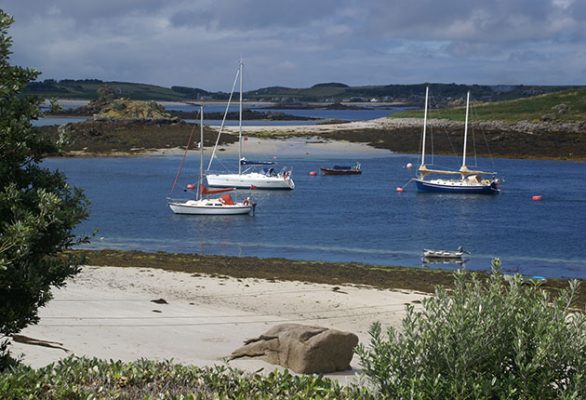
South Seas or home waters? Appletree Bay is a snug anchorage in an east wind. The bay is located on the Tresco side of New Grimsby Sound. Credit: Ken Endean
From here, it is possible to land by tender on the beach.
Alternatively, when swell is breaking on the sand, or you have heavy provisions to transport, it is less than half a mile to the dinghy pontoon in the harbour.
If Porth Loo is crowded, the area north of Taylor’s Island serves as an overspill anchorage, with good shelter close to the shore.
Tucked-in by Tresco
New Grimsby Sound has another batch of visitors’ mooring buoys but, as at Hugh Town, they are popular.
Anchoring room in deep water is restricted by local boat moorings and Green Bay, on the Bryher side, dries at around 2m.

Ken Endean is an inshore pilotage enthusiast who has made a close study of coastal sea conditions around the British Isles
It can also become congested: on our last visit there were 14 yachts at anchor there, all taking the ground at low water.
However, in an east wind, the attractive Appletree Bay on the Tresco side of the sound is tenable, with its elegantly curving beach, sloping to a fairly flat bed of sand, with ample swinging room and good holding.
Some rubble patches in the southern half are easy to identify from their weed.
This is another drying anchorage but only just – the bed level is at around chart datum and MLWS is 0.7m, which means taking the ground at low spring tides, but as MLWN is 2.0m above datum many yachts will be able to remain afloat at neaps.
That’s the essence of intelligent cruising in Scilly: to take full advantage of the many possible anchorages one should either be prepared to take the ground or visit during neaps, when low-water depths will be more generous.
Appletree Bay is convenient for Tresco’s shore facilities, with a small supermarket, a laundry and a fresh water tap in a modern development only a quarter-of-a-mile away, on the southern side of New Grimsby hamlet.
Even closer are the famous Abbey Gardens which overlook the bay.
Northern shelter on the Isles of Scilly
St Martin’s, the third-largest of the islands, is visited by comparatively few yachts because its traditional deep-water anchorage is in Tean Sound, which has some drawbacks.
The best positions are occupied by moorings and I always feel reluctant to leave our boat at anchor there because the currents run fast and much of the bottom is weed on rock.
However, during our last visit a French yacht was lying peacefully in Porth Seal, at the northern end of the sound, sheltered by White Island and Plumb Island.
In westerly weather this inlet would have been subject to swell but in east winds the waves were smaller and the reefs gave good protection.
We had chosen to anchor our Sabre 27, London Apprentice, in one of our favourite corners, the horseshoe-shaped bay on the south side of Tean.
This is another anchorage that dries at low spring tides but a deeper channel winds around the Hedge Rock and if there is some north in the wind it is usually possible to lie afloat by anchoring towards the southern edge of the sands, so that the yacht swings over the channel.
Don’t drop the hook in the channel itself, because there is a cable running along it.
For very low springs, there is deeper water just to the west of Tean, in St Helen’s Pool.
From either of these anchorages, a short dinghy trip will take the crew across Tean Sound to St Martin’s, which has fantastic open-country walking paths along its northern flank and the Seven Stones pub in Lower Town.
There is also a general store, a bakery and several small businesses selling local produce.
Navigating the tricky bits
The charts of the Isles of Scilly show large areas of drying sand and dozens of rocks, which may be disconcerting for first-time visitors, but two factors assist the navigator.
First, most of the drying sands are near to chart datum and well covered at half tide.
Secondly, many of the rock clumps leave their tips exposed at high water, so they can be adopted as beacons for eyeball pilotage.

Credit: Maxine Heath
In the northern part of the archipelago one way to become familiar with these natural aids is to track along transits A or B (see chart above), while observing the rocks and identifying them on the chart.
After that, even a newcomer will possess a bit of local knowledge and will feel more confident about exploring away from the transits.
I refer to this style of navigation as the method of friendly rocks.
A stack that is steep-to on one side is as good as a cardinal mark, while a pair of rocks with clear water between them can serve as port-and-starboard beacons.
Even so, it is as well to have a reasonably calm sea, so that small rock heads are not obscured by waves and breaking crests.
Around the back of Bryher

Credit: Maxine Heath
The western side of Bryher (see above) incorporates an off-lying jumble of islets and reefs known as the Northern Rocks.
It all looks quite frightening when west winds send rollers smashing over the lumps, but during June 2018 a prolonged period of gentle weather with easterly breezes created an unusually calm sea state, and we decided to aim for the inlet known as Great Porth.
I had not seen any published transits or other detailed pilotage advice for this area, so we used the chart to identify some friendly-looking features.
Certain tidal parameters were important for assessing what rocks would be visible and when. Highest Astronomical Tide (HAT) at Scilly is 6.3m, so non-covering rocks are higher than that.
Predicted HW was 4.2m, during the most critical part of our passage, so all uncovering rocks with drying heights of more than 4.2m were likely to be exposed.

Natural landmarks in the approaches to Great Porth, Bryher. Credit: Ken Endean
From the northern end of New Grimsby Sound, our short passage plan was as follows:
After rounding Shipman Head, which is steep-to, track mid-way between Scilly Rock and Gweal. (Gweal has outliers but none near the middle of the gap.)
Identify Moon Rock and track past on its SW side, maintaining that heading as the entrance to Great Porth opens up. (If below half tide, allow clearance for a 0.4m drying outlier alongside Moon Rock.)
Steer into Great Porth on a heading of about ENE, passing close to Gulf Rock and then between the above-water heads that are on each side of the entrance.
That all worked well, except that Gulf Rock, which the chart showed as non-covering (i.e. at least 6.3m above Chart Datum) was only just exposed when we arrived and would be covered at MHWS.
However, there is a higher outcrop on the northern part of Droppy Nose Point.
In future, I would aim to pass mid-way between that rock and the 1m-high outlier south of Merrick Island.
We later reported the discrepancy to the UKHO, and it has been corrected.
Continues below…

Sailing wildlife: 10 best British spots to see various species
One of the great pleasures of cruising the waters of the British Isles are sailing wildlife encounters. The diversity of…

Anchoring: 7 common problems solved
Yachting Monthly experts share the problems they have most often faced when anchoring, and how they troubleshoot their way out

St Agnes, Isles of Scilly
St Agnes is a magical place, the last point of land before the Bishop Rock Lighthouse and the open Atlantic…
St Helen’s Pool, Isles of Scilly
Nestled between the northern islands of the Isles of Scilly, St Helen’s Pool enjoys nearly all-round shelter – a rare…
After the excitement of the entrance, Great Porth was very relaxing: only three small craft on moorings, hardly any people, and we rowed ashore to another long, white beach.
The inlet is overlooked by the Hell Bay Hotel. A short walk up the hill would take a crew to the Vine Café and the Post Office store.
The converted gig shed on the edge of the beach is used by artist Richard Pearce as a studio.
We had anchored in sufficient depth to lie afloat at low water but drizzle was forecast and we wanted to explore a southern route from Great Porth in good visibility, so we sailed out at half tide.
The key feature for our exit plan was the long rock known as Gerwick.
After passing Droppy Nose Point, steer west until the north end of Gerwick is abeam.
Curve round to sail down the SW side of Gerwick, which is steep-to, at an offing of 50-100m. (This slot is known as the Outer Neck of Gerwick. Below half tide, two drying rocks are close to the track but can be given a wider berth by easing over to starboard at the north end of the slot and to port at the south end. The long reef extending SE of Castle Bryher will be exposed to serve as an extra visual aid.)
Maintain the same line, keeping the SW side of Gerwick open, until past Outer Colvel Rock.
After that, we were in open water and tacked back into our earlier anchorage in Appletree Bay.
The next wind shift
If an east wind backs or veers, that may be good news or bad, depending on what weather systems are influencing the airflow.
A north-east wind will often be associated with an anticyclone in the North Atlantic and fine, warm conditions.
There will be deep-water shelter in Porth Cressa, off Hugh Town’s southern beach, and in The Cove, between St Agnes and Gugh.

The Cove, between St Agnes and Gugh, has deep water and fairly good shelter in north east winds. Credit: Ken Endean
The drying anchorage of Higher Town Bay, under St Martin’s, will be snug for shoal-draught yachts and twin-keelers.
In light northerly breezes there are some very attractive spots within the Eastern Isles and also an anchorage close to Tresco’s southern ferry landing at Crow Point.
A wind veering to the south-east is more problematic if low pressure is approaching from the west.
That could mean a strengthening wind, veering through south to south-west or west if the depression tracks past to the north, when anchorages sheltered from the east will become exposed by the veer.
For that kind of forecast, our preferred hiding place is the anchorage at Old Grimsby, which is open to directly south-east but protected as soon as the wind starts to veer.
There and back
No review of the Isles of Scilly would be complete without considering passages to and from the mainland.
In east winds we might expect the outward passage to be a doddle but our last two crossings have shown otherwise.
On each occasion, the wind was about ENE and Cornwall created a long wind shadow, extending halfway from Mount’s Bay to the islands.
Winds to the north and south of the wind shadow were stiff, with breaking crests everywhere, while in the middle we had light airs but waves from the Bristol Channel and the English Channel were criss-crossing in a chaotic sea state.
Our course was set to clear the southbound lane of the traffic separation scheme (see chart below) but if we encounter similar conditions in future I shall diverge to north or south.

Credit: Maxine Heath
For homeward-bound yachts, east winds are obviously unwelcome but the passage should be planned to take account of the rotating tidal streams and forecasts may predict a slant that would favour one tack or the other.
If you find yourself in a wind that is veering towards the south it will often bring hazy or drizzly conditions, whereas a breeze backing through the north-east is more likely to provide an enjoyable crossing on a sparkling sea.
Suggested reading for cruising the Isles of Scilly
Isles of Scilly by Graham Adam/Royal Cruising Club Pilotage Foundation, 6th edition (Imray, £27.50)
Buy Isles of Scilly by Graham Adam, RCCPF from Amazon (UK)
Yachting Monthly’s Channel Havens: The Secret Inlets and Secluded Anchorage of the Channel by Ken Endean, 1st edition (Adlard Coles, £18.99)