


Weather data is getting easier and cheaper to download. Sam Fortescue reviews the latest options and chooses the best weather apps for sailors

Best weather apps for sailors
Rapidly evolving digital technology now allows the sailing community to benefit from a huge range of specialised, easy to use and inexpensive weather apps.
Advanced weather forecasting models are currently being produced by a multitude of meteorological offices around the world, whose supercomputers churn through data of unimaginable complexity, from the charge of particles in the air to convection currents.
Different models have different strong points, and many of the weather apps covered in this survey allow you to select between them, with the more technical ones comparing several forecasts with actual observations in your area and recommending the most accurate.
The best weather apps tend to charge a subscription fee, so it’s worth being clear on where and how you intend to use your boat.
There’s no sense going for PredictWind, for instance, with its offshore weather routing and narrowband satellite mode, if you just want to know what’s happening in your local estuary over the next few hours.
Some weather apps also offer better overseas coverage than others, with global predictions up to a year ahead.
But be aware that you may need to buy a separate subscription to unlock unlimited forward predictions beyond the UK.
Note also that not all the apps offer the same level of support for secondary ports, so check your favourite spots before you buy.
Nor is it always specified whether the apps use UTC or local time, which can give rise to errors of an hour.
Which Met Model?
Weather apps draw on a huge range of meteorological models to gather and present their data, so dig down into the version details to make sure the meteorological model being used by the app will suit your cruising plans.
- ECMWF: European model with 9km resolutions, updated twice daily, and considered the most accurate global model.
- GFS: 27km resolution with four daily updates, from the US. Not so good near coasts, as it doesn’t consider topography.
- ICON: 13km resolution (7km in Europe, making it the best for our continent) including horizontal wind speed. Developed in Germany with
four daily updates. - SPIRE: 12km resolution with intensive use of radio occultation data to provide top accuracy offshore.
- UKMO: Met Office model with 10km global resolution and an exceptional 1.5km in the UK.
- CFS: Produced by the US NOAA for climate-level predictions over nine months ahead.
- WRF: Resolves down to 500m and often used as a basis for other forecasting services.
- OS: Developed in Greece with a 12km resolution – that’s very good in the Med.
- AROME: French model with 1.25km resolution. Reliable around France, southern England, Ireland and as far as the German coast.
- HIRLAM: Collab between 10 European met offices for short-range accuracy.
- NAM: 12km resolution in N America.
- HRRR: 3km resolution for incredible detail over the US.
Best weather apps for sailors
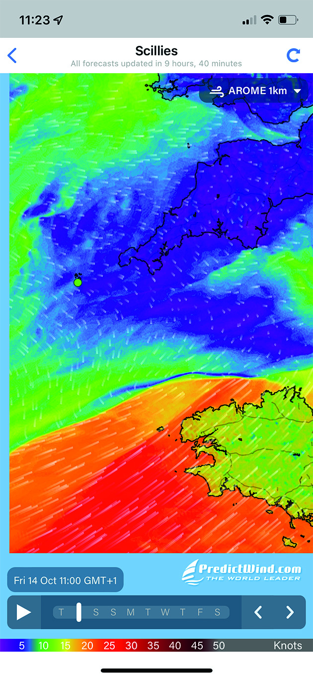
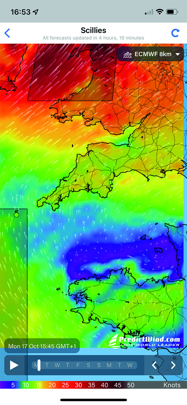
PredictWind
Developer: PredictWind
$29 per year. www.predictwind.com
Fantastic interface, with a slick animated forecast that uses colours to reinforce the data on wind strength.
You can also toggle between traditional wind barbs and arrows, and consult wind, waves, electrical potential, cloud, rain, pressure and temperatures.
The ‘validation’ page lets you identify the most accurate forecast model in your location, but coverage is not universal.
PredictWind is also unique in offering an unbeatable set of tools, including offshore weather routing that analyses wave patterns to calculate how uncomfortable the sea state will be.
It also does GPS tracking and has a narrowband satellite comms version for more efficient offshore forecasting (using a separate Predictwind Offshore app).
There is even a dedicated Predictwind app within the Iridium Go! Satellite communicator.
Subscriptions for the smartphone app range from a free version to $499/yr for the professional package, giving you incredible wave modelling and offshore detail.
But just $29/yr gets you the Basic package with 1km resolution, while the Standard subscription for $249/yr adds in weather routing.
PredictWind has also developed a datalogger ($299) to record NMEA data, track your boat on GPS and put it all together in log files or blog posts, which you can send to a sat phone to put online.
You also become a mobile real-time weather and AIS station for PredictWind.
GRIBView

Developer: Theyr
£11.00. www.theyr.com

Offers 17 different forecast models ranging from super accurate 1.1km resolution wind models of the English Channel to five-mile models of much of the rest of the world.
The free subscription provides wind forecasts at 1º (60nm) resolution. For £8.99/month you get 0.1º accuracy and extra wave data.
The £16.99/month Premium pack includes ice fraction and tidal stream data.
However, if you subscribe for a month at a time (rather than an annual contract), you pay a 30-40 per cent premium.
You can overlay the forecast onto a small scale Navionics chart, but the display feels old-fashioned compared to others as it isn’t animated and uses traditional wind barbs to indicate direction and strength.
Continues below…

How to interpret wave patterns for comfortable sailing
Ken Endean explains how to read the water to find fair tides and avoid rough water

Predictwind Iridium GO! tested at sea – review
Andy Pag puts Predictwind’s IridiumGO! through its paces on an Atlantic crossing to test how good the satellite modem really…

Sailing apps for sailors who cruise
With the high cost of marine electronics, phone apps offer a plethora of affordable navigation data at your fingertips, says…

Tried and tested: tides planner app for iPads and iPhones
Duncan Kent thinks he has found the best Tides Planner App for iPads and iPhones yet
Windy.app
Developer: Windy Weather World Inc.
£8.99 per month. www.windy.app

Aimed squarely at sailors and watersports enthusiasts. Offers wind and wave conditions in thousands of spots around the coast, giving cloud cover, rain and temperature up to 10 days ahead.
Free version provides tide times and heights. Subscribe to access forecasts from numerous detailed weather models.
The PRO subscription costs £8.99/m or £52.99/yr, providing archive info back to 2012, and model comparison and offline forecasts.
Compares the predictions of each model for a given spot then tells you which one has proven most accurate in the past.
A great tool, especially if you’re cruising away from home waters. PRO access also gives you swell data, isobars and HD mapping. (Not to be confused with ‘Windy.com’.)
WindHub
Developer: Windy Weather World Inc.
£58.99 per year. www.windhub.com

Intuitive controls allow you to toggle between weather models on one hand, as well as data including wind, gusts, rain, cloud, swell, pressure and electrical potential.
A slide-away table summarises the data for your chosen point, including a graphical analysis of wind speeds. Very easy to understand at a glance.
Includes information on tidal streams for spots you select with a tap of the finger.
There’s a tidal curve, too, showing high and low water times and heights, although you can’t interrogate it for extra detail.
Offers multiple weather models, but calculates its own high-resolution forecast for Europe and East Asia.
An annual subscription will cost you £58.99 in Europe, but cheaper elsewhere.
Nova Buoys
Developer: Flytomap
£2.49. www.flytomap.com

Real-time weather data from 2,000-plus NOAA buoys mostly around the US coast.
There are some mid-Atlantic and a handful of others around the British Isles. Data varies depending on the buoy type, and can include pressure, wind speed and direction, wave period and air temperature.
Buoy E1 off Plymouth gives wind speed and direction, pressure and air temperature.
The Sandettie Lightship off Dunkirk also gives water temperature and wave height and direction.
Alas, there is no access to past reports that could tell you how conditions had changed in preceding hours.
A graph showing changing pressure or wind speed would be very handy, but there are other apps which do this, such as NOAA NDBC Buoy Live Marine (£4.99/yr).
Squid Mobile
Developer: The Great-Circle
£5.49 per week. www.squid-sailing.com

A good-looking app with core data that includes wind, rain, cloud and wave heights, atmospheric pressure and temperature. \
For the full choice of weather models, flexible subscriptions run from a week (£5.49) up to a year (£29.99).
It offers weather routing calculated in ‘the cloud’ to reduce satellite airtime while offshore and packages weather data so you can download it as a GRIB file for
use on other displays or apps, which is great for blue-water sailors.
Allows you to select and edit the area you want by simply tapping a map.
You can then edit the time period, frequency and exact data you need to ensure it doesn’t clog up your Iridium satellite connection for hours. Good value.
Windfinder
Developer: Windfinder
£1.39 per month. www.windfinder.com

The basic app provides a good animated map of current wind conditions across the globe.
To unlock more detailed forecasts you need to upgrade to Windfinder Plus (£9.49/yr or £1.39/m), which refreshes every six hours.

The basic app gives a 7km resolution in Europe (5km in the US), but coverage is limited to Europe, North America, Egypt, the Canaries and South Africa, so you wouldn’t choose this app to go offshore.
Other nice features include specific ‘spots’ for which you get instant wind, wave and tide read-outs, with 20,000 weather stations and 160,000 spots globally.
Windfinder Plus also offers access to 63,000 webcams and wind alerts. Costs £3.49 to get rid of the annoying ads.
Enjoyed reading Best weather apps for sailors?

A subscription to Yachting Monthly magazine costs around 40% less than the cover price.
Print and digital editions are available through Magazines Direct – where you can also find the latest deals.
YM is packed with information to help you get the most from your time on the water.
-
-
-
- Take your seamanship to the next level with tips, advice and skills from our experts
- Impartial in-depth reviews of the latest yachts and equipment
- Cruising guides to help you reach those dream destinations
-
-
Follow us on Facebook, Twitter and Instagram.