


Sam Fortescue looks at ways to slash the cost of digital nautical charts with his guide to the best sources of free chart data

Are free digital nautical charts any good?
There is one name that comes up first every time in the world of open source navigation.
Open CPN is the best established of all the systems and sets the bar for others in terms of functionality and networking potential. But it is not the only option out there.
With a growing pool of free chart data available around the world, it is getting easier and easier for sailors to escape the magnetic pull of the big chart providers: C-Map, Navionics/Bluechart and now Raymarine Lighthouse.
The main advantage of choosing open source is to avoid the high costs of buying digital nautical charts; costs which have been raised by the possibility of getting digital updates performed automatically on a subscription basis.

Sailing ground off the coast of New York – Open CPN screenshot
You still pay for many digital nautical charts outside the US, where the NOAA has made them freely available, but they often cost less than 10% of the branded charts.
They are best viewed on a laptop, but can also be displayed on a phone or a tablet, further saving the cost of buying and installing a specialist chartplotter.
Good software allows you to connect to your boat’s NMEA instrument network – either by wifi or through a wired USB connection.
In the former case, you’ll need a wifi bridge that is wired into your boat network to collect instrument data and transmit it wirelessly.
If you opt to hard-wire the connection for laptop use, you’ll need a free node on your NMEA 2000 network or an unused NMEA 0183 output close by your laptop.
With this info pouring into your laptop or tablet, plus weather and tide data from an online service, your screen becomes a veritable navigation hub.
You can plan routes with one click and test various scenarios to find the fastest or safest passage plan.
Digital Nautical Charts: OpenCPN
The name stands for Chart Plotter Navigation, and as you’d expect, the aim of the software is to replicate the function of a dedicated chartplotter on a laptop or a tablet.
In fact, you can run it on almost any machine running Windows, MacOS, Linux or Android, but only on Android phones or tablets.
Over the years, the features have developed and the team of developers behind OpenCPN are constantly adding new ones.
Among the latest is the ability to input Signal K (the data format set to usher in the Internet of Things on board) alongside a sophisticated NMEA multiplexer.

Pricing examples for Open CPN’s o-charts
Now in version 5.2, every release has tweaks and improvements.
A very well-specced user interface includes: a full AIS system, with target tracking, selectable MMSI numbers and support for DSC; route planning using tidal data, weather and great circle geometry; plus GPS, alarms, GRIB overlays and support for 20 languages.
It also supports radar images from Garmin and Navico (B&G, Simrad, Lowrance), but not yet Raymarine. Complex installation is now a thing of the past on PCs and Macs, but you do need to download charts separately for the areas you want to cruise.
OpenCPN has a spin-off called o-charts (www.o-charts.org) which packages great value charting data in an encrypted format called oeSENC for vector charts and oeRNC for raster charts.
These cover many popular sailing grounds.
Being run by enthusiasts for enthusiasts, OpenCPN has a lively support community and is constantly evolving new plug-ins for specific tasks.
It is also entirely free!
MacENC
Upgraded and relaunched for Apple laptops by a new developer, NavStation, MacENC now works with 64-bit processors and Apple’s new M1 chip.
It is a complete navigation package that integrates your NMEA data from on board instruments via wifi.
You double click on the chart to create a new waypoint, then add it to a route, overlay radar or AIS data, log your track and export data to a second device for storage or further work at home.
MacENC can obtain tidal data from AyeTides and another nice networking option allows you to export your tracks and routes to Google Earth so that family and friends can follow your progress.
You can use the drop-down menu to select your chart.
It displays the world’s freely provided charts, plus charts you have bought from a retailer of ENC data – it recommends ChartWorld.
Price: €198. www.navstation.net
OpenSeaMap
This is an intriguing German-led project to extend the open data concept to the high seas – as well as inshore and inland waterways.
It comes under the mantle of OpenStreetMap and combines official hydrographic data with user-generated depth, point of interest and navigation mark data.
Drawing data from an army of keen volunteers using a €30-50 hardware logger – you can also use a software logger running on a laptop – the map integrates depth data as it is uploaded and verified.
‘We have seen strong growth in volunteer numbers recently,’ says project head Olaf Hannemann. ‘I think now it has reached the thousands. Most of the depth data is concentrated on the German coast and in the Mediterranean.’

OpenSeaMap screenshot of the East Frisian Islands Intertidal zone
It is free to download in KAP format, which can be displayed easily via OpenCPN, or via the web viewer at www.openseamap.org.
It is also compatible with modern plotters, although you need to use an online service to translate the charts into a format they can read.
For the moment, this product is handy for route planning and longer passages, but you wouldn’t want to use it for nosing into an anchorage on the River Dart – there simply isn’t the accuracy around depth.
However, Hannemann believes that will change as more user data floods in.
It shows fantastic detail of land contours, plus embedded Wikipedia links, AIS data via Marine Traffic and aerial satellite images when online.
Google Earth
In remote parts of the world, charts often rely on data that is centuries old and may be far from accurate.
One solution is to overlay the incredibly detailed and precise satellite imagery from Google Earth, giving you a visual overview that contains the detail you need to spot reefs, rocks and so on.
It is easier than you might think.
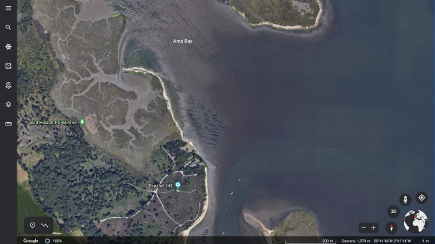
A Google Earth screenshot of Shipstal Point, Poole on the UK’s south coast
You will need a programme called Sat2Chart, created by Paul Higgins (www.gdayii.ca), but if you follow the instructions carefully, it will cleverly combine images from Google Earth with chart data.
The resulting .kap files can be viewed on OpenCPN, and it should also be possible to convert them for reading from a memory card on a commercial chartplotter.
Navico devices use the AT5 file format, while .img files are used by Garmin plotters – conversion software for both is available online.
iNavX
Regularly voted the top navigation app, this only works on smartphones and tablets.
However, it has recently been extended from Apple devices to Android, broadening its appeal and lowering the cost of use.
In terms of specs, this app is second to none, with full support for your NMEA data, from depth and wind to course and speed.
Only the US waters charts from NOAA are accessible free of charge, and are downloadable via the app.
Other waters are covered mainly by Navionics+ or Delius Klasing charts at their usual rates.
Price: €5.49, www.inavx.com
Seapilot
Now owned by Raymarine, Seapilot is a great app for basic navigation.
The chart display is very similar to what you might see on a dedicated plotter, complete with boxes showing data such as SOG and COG.
It is designed for tablets and can be used offline for route planning etc. However, the NMEA data input is limited – just AIS and GPS data as standard, plus depth on Android devices.
No prospect of wind, for instance. You can download charts for countries in Europe for between £8 and £36 – the data comes direct from national hydrographic offices.
But the payment covers just one year’s access to the chart – then you have to buy it again. Updates are included in the year’s subscription.
The basic app is free, or the premium version costs $40 (around £29), which allows you to use your charts on up to five devices simultaneously.
Unless you upgrade, you can’t use GRIB data, AIS or weather routing on the app.
SeaPilot’s other point of difference is its ability to sync with Facebook.
This enables it to easily spot, plot and interact with your Facebook friends on the water.
Price: Free – $40, www.seapilot.com
Conclusion
For laptop use, OpenCPN offers the best combination of flexibility and features.
European cruising can be accomplished easily using low-price vector charting from o-charts.
If you already have the C-Map or Navionics charts, you may be able to use them on OpenCPN. There are also dedicated laptop viewers available.
Synthesising your own charts from a mixture of open source ENCs and Google Earth could be rewarding, but only for those with a bit of time on their hands.
Sadly there is no immediate prospect of the UK making its hydrographic data free to use.
While NOAA gets funding to chart US waters and has to release the data back to the public free of charge, the UK Hydrographic Office operates differently.
‘The UKHO is mandated to deliver its public task and supporting services at no cost to the British taxpayer,’ said a spokesperson.
‘It contributes a proportion of its net profits back to the UK Government. This means that the organisation must be self-sustaining in terms of funding.’
Sources of digital nautical charts
Certain countries have made their hydrographic data freely available, giving rise to completely free digital nautical charts.
These include the US (including Puerto Rico, the US Virgin Islands, Hawaii, American Samoa, Guam and the Marianas Islands), Brazil, New Zealand, Argentina, Peru and the South China Sea.
Inland waterways are also free in Europe, the US and Brazil.
For links to free digital nautical charts, see: www.opencpn.org/OpenCPN/info/chartsource.html
Otherwise, you will have to pay to view charts under licence.
The price you pay depends on who has done the work of extracting and bundling the official hydrographic data.
Continues below…

How to get the latest boat electronics – on a budget
Keeping up to date with the latest navigation technology can be prohibitive. Mike Reynolds shares how to get the latest…

8 tips for digital navigation
As with all aspects of navigation, following ‘best practice’ is the surest way to make sure you are passage planning…
How to choose the right digital charts for your sailing
There are big changes underway in the world of digital cartography, finds Sam Fortescue. We review the latest digital charts

Tech focus: The future of the chartplotter
A new generation of chartplotters offers sailors more processing power than ever before. Sam Fortescue examines what you get when…
For instance, OpenCPN and other navigation software allow you to download and use Navionics or C-Map charts, where you benefit from some of the extra embedded features, but at their higher prices.
A Navionics chart of the UK and Ireland could cost £200-plus.
When using a chart viewer rather than a plotter, you’ll typically download unbranded ‘generic’ chart data from an operator like o-chart.
The not-for-profit (www.o-chart.org) offers astonishing value, with oeSENC vector charts covering the British Isles and Atlantic France for just €29.50, the Caribbean for €29 and Croatia for €27.50.
It also offers raster charts.
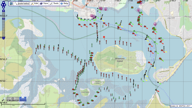
An OpenSeaMap screenshot of Poole Harbour
Between them, these two formats cover North America, part of South America, most of northern Europe and the Med, plus Australia and New Zealand.
The price reflects a small royalty for the hydrographic office concerned.
Outside these areas, you can still download digital nautical charts under the more expensive S-63 licence system, where you pay fully commercial prices – a tiresome necessity if you are chartering the boat or using it for any other commercial purpose.
Here, ChartWorld offers decent folio deals in some areas, such as the Gulf, Indonesia, Borneo, Cuba, Iceland and South Africa for €25-75. Otherwise you have to buy charts singly, where each one costs £15-£20.
Enjoyed reading Free digital nautical charts: are they any good??

A subscription to Yachting Monthly magazine costs around 40% less than the cover price.
Print and digital editions are available through Magazines Direct – where you can also find the latest deals.
YM is packed with information to help you get the most from your time on the water.
-
-
- Take your seamanship to the next level with tips, advice and skills from our experts
- Impartial in-depth reviews of the latest yachts and equipment
- Cruising guides to help you reach those dream destinations
-
Follow us on Facebook, Twitter and Instagram.