


The Yachting Monthly team look at the latest navigational technology and how useful it is for the cruising sailor

The latest navigational technology: new gear for your boat
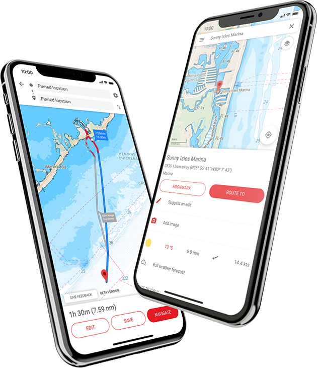
New navigational technology: Orca Co-Pilot Navigation System

For anyone who has struggled with the usability of multi-function displays (MFDs), the Orca co-pilot claims to have ‘reinvented marine navigation’ with a system that combines accurate charts, live weather forecasting, intuitive alerts and automatic route-finding at the push of a button.
It supports wireless internet connectivity and so, whilst you have active cellular connection, updates charts and synchronizes routes across devices without using SD-cards or other complicated methods.
When offshore and without connectivity, the system is still functional with pre-downloaded data.
The question that inspired Norwegian marine tech start-up Orca was: ‘Why do more than 70% of boaters with a dedicated marine navigation system also feel they need mobile applications while they plan and navigate at sea? What kind of value did these mobile apps bring, that the MFDs could not?’
Orca co-pilot aims to avoid sailors relying on mobile apps to supplement their chartplotter, which forces attention to shift between multiple screens and systems instead of focusing on surroundings.
The Orca Core integrates with your boat via the industry-standard NMEA 2000 protocol, and works either on the Orca Display – a 10.1-inch full-HD outdoor viewable screen and mount with integrated charging – or on the user’s own tablet.
Prices start from €449 for the Orca Mobile Kit, which contains the Orca Core and a year’s App subscription.
The Orca Display Kit (€1,499) includes all of the above plus the charging mount and display.
Thereafter a subscription to the cloud services costs €120 per year, and gives access to: continuous chart updates; advanced weather forecasts and monitoring services; cloud-powered automatic routing; cross-device synchronisation and trip analytics with insights into fuel consumption, and early warnings of abnormal engine behaviour.
Price: From £428
New navigational technology: B&G App Mobile Navigation
The free-to-download B&G App offers all users the chance to view up-to-date detailed nautical charts from C-MAP, add personal waypoints, routes and tracks, the latest marine weather, and add personalisation.
A ‘premium’ subscription service costs £48.99 a year and includes GPS location and full navigation; global offline maps; five-day weather forecasting; high resolution bathymetry; custom depth shading; Automatic Identification System (AIS); shaded relief charts and a view of other App users’ ‘traffic’.
For B&G chartplotter owners, the B&G App can be used onboard as an extension of your display by using the mirroring and control feature.
It is available via the Apple Store for iOS and Google Play for Android.
The App can also be used to review past sailing trips or races, get the latest software updates, product news, manuals and ‘how to’ tips specific to your registered devices.
Subscription: £48.99
Continues below…

Shorthanded sailing: the latest new gear
The Yachting Monthly team round up the latest marine kit for shorthanded sailing, from electric winches to furlers

Autopilot Buyers Guide for sailing yachts
There’s a bewildering array of options available for pilot systems, Rupert Holmes explains how to choose a suitable autopilot system…

8 tips for digital navigation
As with all aspects of navigation, following ‘best practice’ is the surest way to make sure you are passage planning…

The best multitool for boating: 10 tested
A multitool is a toolkit in your pocket for when you need it the most. The Yachting Monthly team put…
New navigational technology: Inmarsat Elera Narrowband Network

Inmarsat has unveiled ELERA, a global narrowband network that is expected to rapidly evolve the Internet of Things (IoT) – objects with computing devices embedded that enable them to send and receive data.
Described as an important evolution of Inmarsat’s market-leading L-band satellite network – the L band is one of the chief operating ranges used by applications such as radar, GPS, telecommunications, radio, and aircraft surveillance – ELERA is ‘significant’ for seafarers as it will offer global reach and greater resilience, meaning sailors can always be connected wherever they are; making it easier to keep in touch with friends and family, access weather reports and navigation charts, as well as email and business-critical applications, and not least safety-of-life communications.
It will incorporate new innovations ranging from faster speeds, up to 1.7Mbps, to the smallest low-cost terminal for ELERA users; delivering the framework for satcom IoT at scale, with supporting cloud-based management.
Inmarsat is launching two new satellites to enhance the ELERA network – with the first launch scheduled later this year.
The L-band capacity on each I-6 satellite will be far greater than previous generations of Inmarsat spacecraft, delivering 50% more capacity per beam, meaning that customers can count on much more data to be carried over the same geographical area, in addition to unlimited beam routing flexibility.
Price: POA
Enjoyed reading this?

A subscription to Yachting Monthly magazine costs around 40% less than the cover price.
Print and digital editions are available through Magazines Direct – where you can also find the latest deals.
YM is packed with information to help you get the most from your time on the water.
-
-
- Take your seamanship to the next level with tips, advice and skills from our experts
- Impartial in-depth reviews of the latest yachts and equipment
- Cruising guides to help you reach those dream destinations
-
Follow us on Facebook, Twitter and Instagram.