


Screen grab from US Coastguard given to rescue yachts
A screen grab of an area of 100 square miles of ocean in which it is believed the four UK missing yachtsmen either are or where they disappeared has been released by the US Coastguard.
The screen grab was sent to the ARC Europe yacht now searching the area for signs of life or debris.
World Cruising Club also released a blow by blow account of what is known to have happened provided by USCG:
*The first of 2 Personal Locator Beacons (PLBs) was activated at 38-45N, 048-00W 0410 UTC 16 May 2014.
*If the crew managed to launch a life raft, it is likely they did so at this position.
*The 2nd PLB ceased transmitting at 38-34.9N 048-15.4W 2310UTC 16 May 2014. (Note: PLBs have relatively short battery lives as they are intended as a man-overboard locator, not as a yacht distress beacon).
*An upturned yacht that has lost its keel was seen at 38 15 N, 048 38W on Saturday 17 May. The yacht has not been identified, but it is highly likely to the be distress vessel.
USCG has provided an updated drift of 37-52.8n 048-24.2w. This is the centre of an ever growing search area.
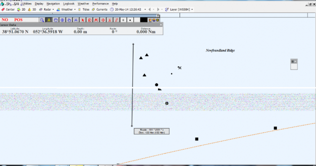
The screen grab shows plots of positions and possible area of drift. The rhumb line from Bermuda to Horta (Azores) is running along the bottom left to right. The last known position is 120 miles from the rhumb line.
X marks the last known GPS position from Cheeki Rafiki, two smalldots are PLB signals. The wreck symbol = sighting of upturned hull. The three triangles = possible drift of upturned hull calculated by the rescue yacht Malisi given wind conditions over the weekend, and the black dot with cross = centre of US coastguard search area. The black dot = latest position for Malisi.
WCC’s Jeremy Wyatt said: ‘This time of year there are lots of boats heading back to Europe from the Caribbean, and where possible boats are attempting sail through the drift zone. The sailing community is spreading the word widely to try and reach as many boats at sea, as possible.’